
Tree rings serve as natural archives, capturing Earth’s climate history through their growth patterns, density, and chemical composition. Each ring holds valuable clues about past environmental conditions, recording events such as droughts, wildfires, insect outbreaks, and long-term climate shifts. This field of study, known as dendrochronology, allows scientists to reconstruct the timing and intensity of historical climate events, providing critical insights into long-term climate patterns. Researchers at Wuhan University have advanced this method by integrating hyperspectral imaging, significantly enhancing the precision and depth of climate reconstructions while addressing gaps left by limited instrumental climate data.
What is Hyperspectral Imaging?
Hyperspectral imaging (HSI) is a sophisticated technique that records the spectral properties of objects across a broad range of wavelengths. By detecting subtle variations in how materials reflect light, a hyperspectral camera enables precise classification, analysis, and identification of different materials. Unlike conventional imaging methods that rely on wide spectral bands, HSI captures data in continuous, narrow spectral bands. This allows for a more detailed examination of surface characteristics, uncovering information that can be linked to biological, biophysical, or chemical properties.
Given the enormous volume and complexity of data generated by hyperspectral cameras, advanced data processing techniques such as Principal Component Analysis (PCA) are used to extract meaningful information. PCA reduces the dimensionality of hyperspectral data by identifying patterns and highlighting the most significant spectral features, making it easier to interpret and visualize. This technique helps emphasize variations and correlations within the data, enhances the accuracy of material classification, and enables more efficient analysis of complex datasets.
Hyperspectral Imaging Benefits
The research team at Wuhan University turned to hyperspectral imaging to address the limitations of traditional methods in regions with poor signal strength, such as areas impacted by low temperature and water stress. These conventional approaches often require an impractically large number of samples to achieve reliable climate reconstructions. The team analyzed tree core samples collected from Shennongjia, a region in northwest Hubei Province, China. The collected tree species is Abies fargesii, which is endemic to central China. Shennongjia’s mild, rainy climate is not typically conducive to studying past climate patterns using tree rings, as the conditions can obscure clear signals. However, hyperspectral imaging offers a solution by enabling the detection of subtle variations in tree-ring properties. This technology enhances signal strength and significantly reduces the need for extensive sampling, making it a powerful tool for reconstructing paleoclimates in challenging environments. By maximizing data quality from limited samples, hyperspectral imaging proves particularly valuable in regions where traditional methods fall short.
Hyperspectral Microscopy Setup
Researchers designed a microscopic hyperspectral imaging system comprised of:
- Microscope with electronic display output
- Sliding platform (LINTAB Chronology Analyzer)
- Stable full-spectrum light source (50 W/3200 K halogen lamp)
- SOC710 hyperspectral imager (Surface Optics Corporation)
- Computer
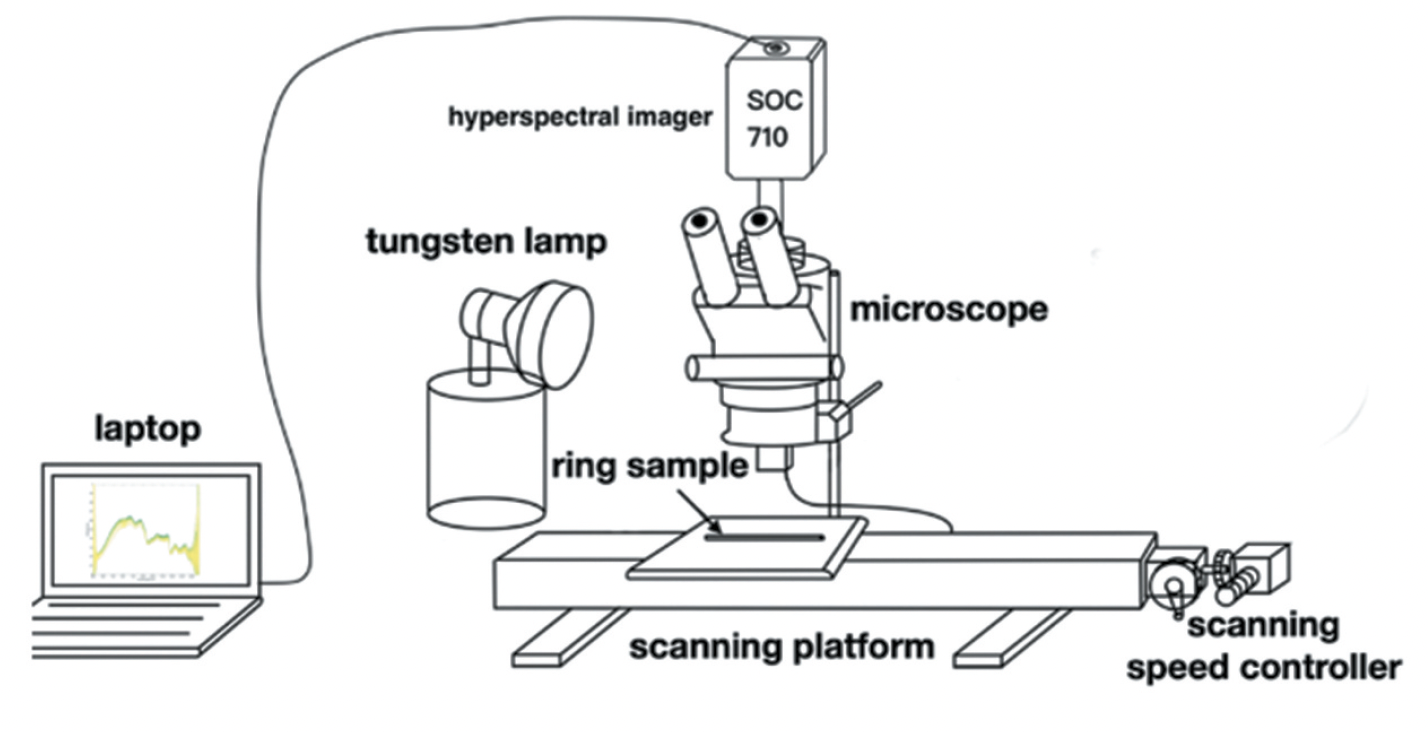
The system was set up in a room with a full-spectrum halogen lamp as the only light source. A tree ring sample was placed on the moving stage beneath the microscope, which was systematically advanced at fixed intervals between image acquisitions. This controlled movement ensured sufficient overlap between adjacent images, enabling seamless stitching to generate a complete picture of the entire tree ring. The SOC710 hyperspectral imager captures 128 wavebands covering a spectral range from 372 nm to 1039 nm; acquired spectral images have a 696 × 510 pixel resolution.
Hyperspectral Imaging vs Traditional Methods
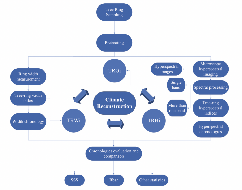
The ARSTAN program was used to generate a width index, grayscale index, hyperspectral indices, and corresponding chronologies to evaluate the effectiveness of tree ring spectra for paleoclimate reconstruction. A flowchart illustrating the experimental methodology is presented in Figure 2.
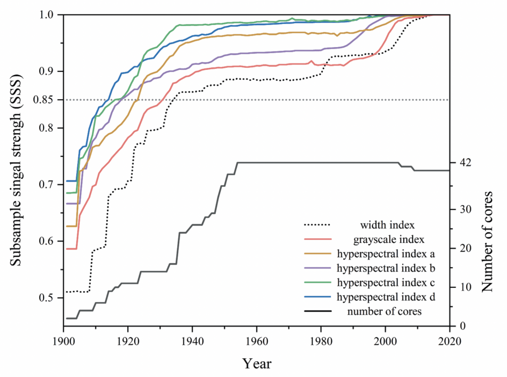
Results of the study demonstrate hyperspectral indices can provide reliable data in more years with a smaller sample size for past climate reconstruction than the traditional width index. As shown in Figure 3 below, the conventional width-index method needed at least 16 tree ring samples to meet the requirements of accurate climate reconstruction, and the first year of climate construction was 1935. In contrast, hyperspectral indices required only 9-14 samples, and earlier years of climate construction were obtained, going as far back as 1914.
A significant portion of hyperspectral imaging research is dedicated to identifying the specific spectral bands necessary for a given application. While hyperspectral sensors collect data across hundreds of contiguous bands, most real-world applications do not require the full spectral range. Thus, researchers often focus on determining which bands carry the most relevant information for their use case. Band selection is crucial because reducing the number of spectral channels improves processing efficiency, reduces data storage requirements, and enhances real-time applicability. In this case, the Wuhan University team identified the bands centered at 473 nm, 565 nm, 596 nm, 653 nm, 768 nm, 838 nm, 875 nm, 897 nm, 934 nm, and 1011 nm, for tree ring surface spectra-based paleoclimate reconstruction.
In conclusion, in warm and humid regions, the width index is less effective for climate reconstruction, whereas this study found that a hyperspectral index offers greater accuracy in paleoclimate studies. This improved precision could help uncover new insights or refine existing theories about natural and historical events linked to paleoclimate change.
To read the full research publication, see:
Yinghao Sun, Teng Fei, Yonghong Zheng, Yonggai Zhuang, Lingjun Wang & Meng Bian (2024), Improving signal strength of tree rings for paleoclimate reconstruction by micro-hyperspectral imaging, Geo-spatial Information Science, 27:5, 1657-1674, DOI: 10.1080/10095020.2023.2264913